Sunday, September 13, 2015

Hidden Gym of the North Georgia Mountains: Hiking Cloudland Canyon

Hiking Cloudland Canyon East Rim
Though hiking the north Georgia mountains is a popular recreational activity for people across the state, few of its residents are fully aware of the secret adventures hidden throughout the region.
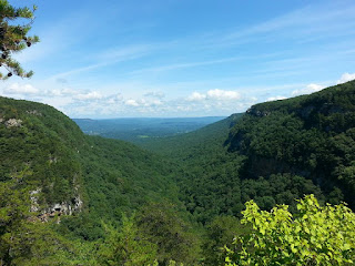
The north Georgia mountains are full of hidden adventures and secret opportunities.  That's why I often find it more fun to drive through the area without a plan and let adventure find me.  One of the most unique and is hidden away in northwest Georgia, not far from Rock City.  Unknown to most Georgians, a river cuts through the famous Lookout Mountain, carving an actual canyon along its way.  One of only three in Georgia, Cloudland Canyon is widely considered to be the most beautiful of the trio.  From the top, visitors can enjoy across the canyon extending to a valley, with thick forests below.  At first glance, this appears to be all the canyon has to offer.


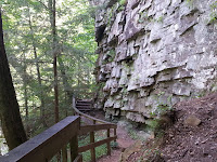
Cloudland Canyon Rock FormationHowever, a 1500 foot hike down the stairs reveals an entirely new world.  There is much more to be discovered, and it doesn't take long to find.  For me, I chose to follow the waterfall trail down the east wall of Cloudland Canyon.  As I began to descend, I was immediately greeted by unique rock formations and small streams trickling along the mountainside.  As the wall became more steep, its edge's features also grew more jagged.  The walkway wraps tightly around them, putting hikers within arms-length of the canyon's rich geological history.  The wall looks like a climber's dream, though I'm sure scaling it would (unfortunately) be frowned  upon by park officials.


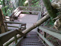
Tree Down on the Hiking PathContinuing down, I noticed that 2 segments of the path were blocked by the same fallen tree. Several hikers decided to turn around, but it was easy enough to climb over.  As I continued to descend, the rock formations grew in size and prominence.  The roaring of the river also became louder.  A sign reveals waterfalls at each end.  The canyon narrows to my left, so I head that way first.  A short hike over some rocks and through the woods revealed a waterfall over 80 feet high.


Past that, I continue my hike to the west wall of Cloudland Canyon. I found an unusual rock formation with small streams of water flowing down its ridged edges.  Beyond that, though, this section appears to be less scenic, though it does offer a view of my strarting point from the top.  There's also a small cave along the trail, though it won't fit more than 2 or 3 people.


Hiking a Cloudland Canyon WaterfallBack at the bottom, I begin to discover the features that really make Cloudland Canyon famous: the waterfalls.  The trails run along a creek on the canyon floor.  Hemlock Falls is among the first to greet visitors, though it was running a little light today.

Cloudland Canyon West Rim ViewContinuing down, the trail leads to a grated pass high above the creek before descending to the next waterfall.  Tip: if you're afraid of heights, don't look down on this particular segment of the walkway.  It's a fairly high drop, and the grates are spaced enough to see the bottom pretty well.  After the descent, the trail continues to the left of the falls. To reach it, a bit of a climb is required.  I'm not entirely sure how park rangers feel about people climbing down there, but several others (including children) had already done so.   At the bottom, it is entirely possible to walk through or under the waterfall, though the rocks are slippery.  The pool forms a smaller fall just beyond before continuing down the canyon.
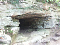

Cloudland Canyon Hiking Trail CaveA bit further down, the river forms a smaller, more secluded waterfall can be found between a few large rocks.  Beyond that, the trail becomes a bit less scenic before it eventually runs into Bear Creek at the cross-way of the canyon.  I decided not to venture that far for now, though I'm sure that I will have another chance to explore the area sometime this autumn.


Hemlock Falls in Cloudland Canyon
Tree down on the hiking path
Cloudland Canyon Rock Wall Path


Sunday, April 6, 2014

North Georgia Tri-Mountain Hike: Monadnock Madness!


Georgia has three monadnocks, all within a relatively short drive of Atlanta.  Stone Mountain easily remains the most popular, but many hikers actually enjoy the scenery of Arabia and Panola mountains even more.  Each spring, outdoors enthusiasts get the opportunity to explore each and learn about their ecology during Monadnock Madness. 
During Monadnock Madness, tour guides lead visitors to the summits of Georgia’s three monadnocks, describing the unique history and geology of each along the way.  While located well below the line of what is typically considered the North Georgia Mountains, our hike would still introduce us to some of the most unique ecology and geology found within the peach state. 
Weather forecasts predicted excessive rain throughout the day.  Fortunately, we never saw more than a few drops, but the threat of inclement weather kept most visitors away, allowing us to have the trails largely to ourselves.  


The event kicked off at Stone Mountain Park just after 3:00 PM.  Although the original plan was to meet in the Education Annex parking lot, we were permitted to instead park at Confederate Hall due to the lack of visitors.  This put us right in front of the trailhead that would begin our tri-mountain adventure.  Though largely vacant today, the unfortunate side to the park having so many visitors is that Stone Mountain’s natural features are largely eroded.  Still, some vernal pools could be found during the ascent, offering quick glimpses at some unique flora colonies. 
Though the rain had subsided, clouds still block most of the significant views.  Though Stone Mountain is known for its overlooks of Atlanta and the North Georgia Mountains, the cloud cover presented a thick fog that obscured any views beyond the mountain’s surface.   It also promoted a more ambient atmosphere during the hike, with a landscape that resembled a horror movie scene.

Foggy Day for Monadnock Madness on Stone Mountain


The rainwater runoff that continued cascading down the mountainside was sure to provide a greater challenge for our hike.  However, it also brought out the solution pools that are normally damaged by heavy foot traffic.  The guide drew our attention to a few pools along the way that featured diamorpha colonies that remained surprisingly intact.  He also indentified various features of the mountain, including crevices caused by volcanic pressure and messages carved into the mountains decades ago. 
Upon reaching the top, we were allowed into the restricted area fenced off from the rest of the park.  Inside, the natural features of Stone Mountain remained better preserved.  The fence drew a clear line between the protected and public areas of the mountain.  A thin moss covered the surface, while solution pools offered a look at some highly delicate (and endangered) plant species.  While the area is fenced off to preserve these habitats, it also ensures the safety of visitors, as a steep drop down the mountainside remained obscured by fog just a short distance away.  We were well advised to stay close to the fence, and no one in our group dared to tempt fate.
The hike back down proved even more challenging, as the cascading water would attempt to expedite our descent.  After carefully hiking down the steepest portion of the mountain, the guide decided to continue through a wooded area, a surprising site for the surface of a granite mountain.  The early signs of spring could be found throughout, including some plants native to monadnocks. 
Next, we headed over to our second monadnock for the day, Arabia Mountain.  At a quick glance, Arabia appears similar to Stone Mountain, but it wasn’t long into the hike that we began to discover an incredibly unique ecosystem.  Given the reduced foot traffic, Arabia Mountain’s environment is far more intact.  Vernal pools could be found throughout, each featuring colonies of unique, endangered plant species.  Aside from the pools, the area is about the closest thing to a desert that can be found in Georgia.  It naturally features plants that are commonly native to arid environments.  The prickly pear cactus and are just some of the desert-like plants found on the monadnock, and the mountain’s surface temperature regularly exceeds 110 degrees during summer months.  As we neared Arabia Lake, we could see rainwater runoff combining with some of the mountain’s natural springs to form what could only be described as a shallow river cascading down the surface.  While the water never seemed to reach more than a few inches in depth, small rapids formed in some areas. 
Our final destination would bring us to Panola Mountain State Park.  Here, we would find an environment similar to that of Arabia Mountain, but even better preserved.  However, we would also enjoy the rare opportunity to see the special glow of the granite monadnock’s solution pools that only appears with the evening sky.  Unlike the other two monadnocks, Panola Mountain has never been quarried, leaving the full natural features intact.  As such, this is also the most strictly protected of the three, as hikes to its summit are only available with a qualified guide.  Fortunately, we had two knowledgeable leading our group.  As we hiked to its surface, the sun began to set, allowing the red diamorpha to contrast well with the dark blue sky reflecting in its solution pools.  As we reached the peak, we found a particularly well preserved pool surrounded by moss in a setting that seemed almost alien.  It was here that we were given our award for completing the epic hike, a commemorative bandana perfectly suited for future adventures.


Even though the prize had been given, the trip wasn’t quite over yet.  We still had to get back down the mountain, but our descent would lead us down one of its steepest sections.  Despite not seeing more than a few drops of perception, some moisture still remained from the morning showers, making the already challenging descent even more perilous.  Our event guides showed us a special sidestepping technique to make the hike down safer, but some of us chose a more exciting method.  Rather than working against gravity, we chose to get down on our backsides and let it carry us to the ground.  Our group of adults found their inner child very quickly, and what could have been a nerve-wrecking, ankle splitting experience turned out to be a fun time for all.  Even with the sky growing darker, we could still make out the silhouettes of large boulders under the thick canopy of forest as we trekked back to our makeshift parking lot. 


Wednesday, February 19, 2014

Hiking the Appalachian Trail to Dockery Lake in the North Georgia Mountains

Hike Date:  02/15/14
Total Distance: 11 miles (roundtrip)
Elevation Gain: 2000 ft
Total Elevation: 3600 ft

Just north of Dahlonega, GA, highway 60 provides access to one of the most convenient sections of the Appalachian Trail's 82 mile run through Georgia: Woody Gap.  Situated just south of Big Cedar Mountain, the AT provides stunning views of the Appalachians before offering access to a variety of trails, many of which form loops back to the parking lot.  Another path, the Dockery Lake Trail, guides travelers along scenic creeksides and foothills before reaching a beautiful north Georgia vista.  This would be my destination for the hike.

The trail from the parking lot continues through the woods for some distance before reaching Big Cedar Mountain.  It had only been a few days since the second of two (so far) crippling ice storms slammed into Georgia, proving especially catastrophic in Atlanta.  Plenty of snow and ice remained (about 4-6 inches), allowing for a particularly scenic landscape.  The nearby trees appeared to have frozen in the wind, which still tore across the region well above the 30 mph range.  Unfortunately, the temperatures were still in the 20s, so a few extra layers were in order.
Shortly after passing a small restroom, a sign guides visitors north along the Appalachian Trail.  After spending some time hiking through the woods, the trail begins its ascent towards the summit of Big Cedar Mountain.
The path leading up seems reminiscent of a typical mountain pass, escalating as a winding trail rather than a straight shot to the top.  However, the path does become more steep when nearing the top.  It does mean a more strenuous climb (especially in the snow), but one well worth the effort after reaching the top.  Hikers are rewarded with incredible views of the surrounding mountains, enhanced by the unique foliage native to this region.  Today, however, the landscape was obstructed by an abundance of clouds.  Fortunately, this is the first of two major overlooks for Big Cedar Mountain.  Continuing north on the AT, I was led to a small side trail with a similar outcropping dubbed Preaching Rock.  Here, the clouds were thinner, and the rising sun silhouetted the mountainscape against the horizon.  I took some time to relish in the unique scene before continuing down the mountain. 

After descending the other side of Big Cedar, the Appalachian trail continues north along a gap to the intersection with Dockery Lake Trail.  This path leads just over 3.5 miles east to, you guessed it, Dockery Lake.

It starts off as a pretty straight forward trail, but soon offers some interesting twists.  Shortly after descending from the gap, Dockery Trail takes a new form, looking less like a trail and more like a channel.  It almost seems designed to funnel water down the hill, though currently covered in snow.  I found myself wishing that I had an innertube handy, as it would surely provided a more thrilling descent.

At the next turn, the trail shifts left and runs along a nearby stream.  A unique selection of plant life grows along its shoreline.  The trail eventually turns again, temporarily leading away from the stream before twisting around and leading over it.  Like the nearby segment of the AT, this trail features several stream crossings.  Most are easy enough with a few cautious steps on the stepping stones, but some were a bit deeper than usual due to the melting snow.

Shortly thereafter, the Dockery Lake trail leads through a dark hemlock forest that, while exquisite, makes it a bit difficult to stay on track in certain areas.  The light blue blazes become less common, so I had to rely on footprints embedded in the snowy terrain to guide my way.
 
After the forest, the trail begins to twist around the outer rim of some nearby foothills.  From here, I caught a few mostly clear glimpses of some nearby snow capped mountains.  It was a sight as rare as it is beautiful while hiking in the North Georgia Mountains.  I was reminded of a few trips up to Smoky Mountain National Park.


 After clearing the foothills, the path leads through a more forested area while running alongside a creek.  As I neared the lake, I could hear the sound of rushing water growing steadily louder.  The stream seemed to be increasing in width, so I was expecting to find some rapids up ahead.  However, I discovered something even more impressive: a waterfall cascading down the side of a nearby foothill.  Such a sight was not expected for this hike and greatly enhanced the overall experience.  A short hike away, I found its source: Dockery Lake.
 The vista presented a serene setting, the perfect resting spot after the long hike.   A wooden dock partially circled the rim of the lake and connected with trails leading into the woods.  A mountain rose above the bank in the distance.  The clouds had mostly cleared, allowing the sparking lake to reflect the clear blue sky.


 I decided to forgo the nearby trails and save my energy for the snowy hike back. It turned out to be a wise decision, as hiking back out proved to be a much greater challenge.  With each step forward, I seemed to slip half of a step back.  This was the case for the better part of Dockery Lake Trail.  Oddly enough, the hike back to top of Big Cedar Mountain via the AT was much easier.  The sky had begun to clear, providing great views of nearby snow-capped mountains during the ascent.  At the top, the overlook so ridden with clouds earlier had also cleared, providing incredible panoramic views of the north Georgia mountains.  This was, by far, one of my most challenging and fulfilling hikes. 

More pictures to come.